
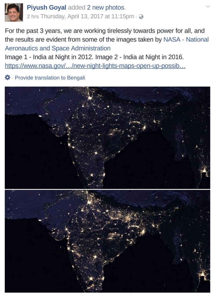
Rightlog, formerly Frustrated Indian, has written a piece claiming to have exposed Alt News regarding the piece we had written where we have claimed that both the media house DNA and the Power Minister Piyush Goyal are misleading the country when they claim that it is his work in the area of power that has led to India looking brighter in the NASA’s recently released globals maps of earth at night. We stand by what we wrote and we’ll explain why.
Rightlog has quoted a bunch of statistics but since they do not believe in giving the source of their statistics, we cannot verify the data they have provided. Besides the table in which they have given some data with regards to rural electrification, they have quoted statistics such as electricity given to BPL households and LED bulbs distributed with the stress on LED bulbs being brighter. Firstly, what needs to be understood is that the image that NASA has presented is actually a compilation using data from a sensor aboard the NASA-NOAA Suomi National Polar-orbiting Partnership satellite launched in 2011. This satellite is at a distance of 833 kilometres from the earth’s surface. The satellite doesn’t peer through your roof to look at the LED bulbs glowing inside your bedroom, irrespective of how bright they are. Las Vegas is one of the brightest cities from the space not because of household lights but because of the enormous amount of city lighting. NASA clearly states that the sensor aboard this satellite observes gas flares, auroras, wildfires, city lights, and reflected moonlight.
But since folks at Rightlog insist on electrification data, we also have some data to present. The night maps that were compared were based on the images released by NASA in 2012 and 2016. 2012 to May 2014 is the period where UPA was governing the country, whereas May 2014 to 2016 period has been governed by NDA. To have a scientific discussion about how rural electrification could have contributed to brighter spots, we present electrification data from Central Electricity Authority dated 31 Jan 2012, 30 April 2014 and 31st December 2016.
30 April 2014 – http://www.cea.nic.in/reports/monthly/electrification/2014/village_electrification-04.pdf
31 December 2016 – http://www.cea.nic.in/reports/monthly/electrification/2016/village_electrification-12.pdf
According to the above data, the cumulative electrification of villages across India as on 31-01-2012 was 552947, on 30-04-2014 was 571168 and on 31-12-2016 was 590488. That would mean, in the 27 months from 31-01-2012 to 30-04-2014, 18221 villages were electrified, whereas in the 32 months from 30-04-2014 to 31-12-2016, 19320 villages were electrified. The rate of electrification in the former period under UPA comes to 674.85 villages per month while the rate under the latter period under NDA comes to 603.75 villages per month. So between the two sets of pictures by NASA in 2012 and 2016, UPA achieved a greater rate of electrification than NDA.
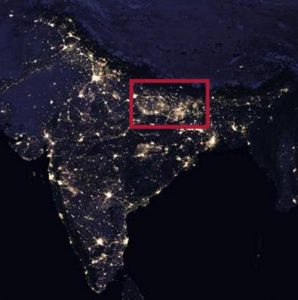 In fact, if we look at the brighter spots on the map, for ex. one that roughly corresponds to the state of Bihar, if we are suggesting that India is looking brighter because BJP’s work in electrification, that would mean that BJP should show greater amount of work in those areas. From the CEA data, the amount of cumulative electrified villages in Bihar as on 31-01-2012 was 34089, on 30-04-2014 was 37002 and on 31-12-2016 was 38452. Thus, 2913 villages were electrified in the 24 months under UPA while only 1450 villages were electrified in the 32 months under NDA. So, if rural electrification is what is leading to bright India, then India did better under UPA according to the statistics above.
The piece at Rightlog further talks about “Intensive Electrification” as a reason for India appearing bright. They state:
However, a little known fact is that the flagship scheme of Deen Dayal Upadhyaya Gram Jyoti Yojana (DDUGJY) under which this drive is being conducted is actually not just limited to these unelectrified villages. A major part of the scheme is to strengthen the existing infrastructure in all the nearly 6,00,000 villages of the country in which many hamlets and households still do not have electricity (This is called intensive electrification.
Fact is everything that is being done under DDUGJY was first announced in April 2005 under Rajiv Gandhi Grameen Vidyutikaran Yojna (Page 25) and Intensive electrification was done in 3,01,261 villages over 10 years which is close to 30,000 villages per year.
According to the data on Rightlog, for the period of 2014-2016 under NDA, 14255+39236 i.e. 53491 villages were intensely electrified. The average is 26745 villages per year, which is again short of the rate than what it was under UPA. So, how does Rightlog conclude that it is NDA’s electrification work that has caused the bright spots?
However, if electrification had actually been the criteria, then why does the Australia which has long been a 1st world country look so dark and gloomy?

Which brings us to the point that we raised in the second paragraph, that the sensors on the satellite look at city lights and density of city lights roughly correspond to the density of urban population. From a distance of 833 kilometres, areas that have a higher population density which is almost always urban areas look brighter. It as simple as that and has got very little to do with household electrification. An article on CNN which compares the 2012 and 2016 night maps of India suggests the same. The CNN report states:
New satellite imagery released Thursday by NASA shows the vast growth of Indian cities in recent years.
Huge swaths of northern India, relatively dark in 2012 night shots, are lit up by huge new urban areas in imagery from 2016.
According to the Oxford Economics Global City Forecast, of the 20 fastest-growing cities in the 2015-19 period, fourteen are in India.
To confirm this hypothesis, we overlapped a map of major cities of India on the 2016 NASA night lights map.
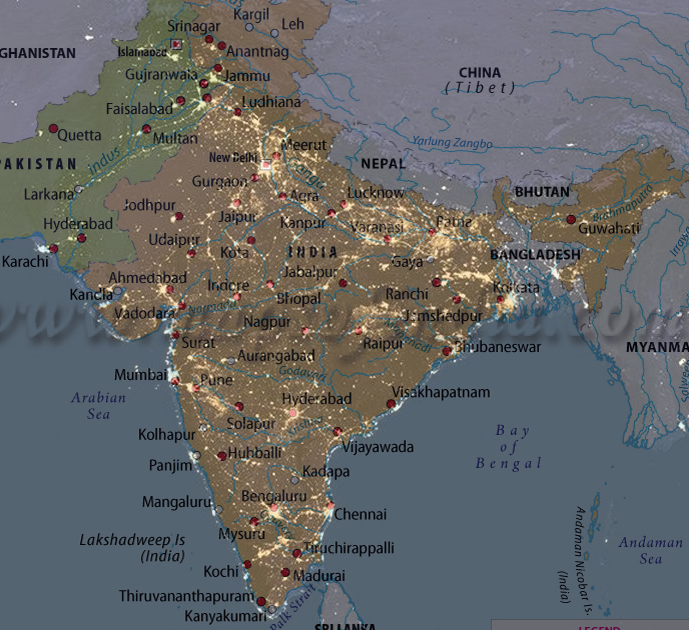
One can see how every city coincides with a spot of bright light on the map, from Ahmedabad to Mumbai to Pune to Bangalore to Hyderabad to Delhi and even cities in Pakistan. Dhaka is not labelled on the map but there’s a giant bright spot on the map where Dhaka would have been otherwise. Is Piyush Goyal working for electrification of Pakistan and Bangladesh too or is it more likely that all the cities in the sub-continent are increasing in size?
The NCR area which includes Delhi, Noida, Gurgaon etc is the brightest spot in India because it is one of the fastest growing and also one of the largest urban areas in the world with a population of 46 million. Rural electrification eh?